Saturday, August 1, 2026
Village Voice News
ADVERTISEMENT
  • Home
  • News
  • Sports
  • Editorial
  • Letters
  • Global
  • Columns
    • Eye On Guyana
    • Hindsight
    • Lincoln Lewis Speaks
    • Future Notes
    • Blackout
    • From The Desk of Roysdale Forde SC
    • Diplomatic Speak
    • Mark’s Take
    • In the village
    • Mind Your Business
    • Bad & Bold
    • The Voice of Labour
    • The Herbal Section
    • Politics 101 with Dr. David Hinds
    • Talking Dollars & Making Sense
    • Book Review 
  • Education & Technology
  • E-Paper
  • Contact Us
No Result
View All Result
  • Home
  • News
  • Sports
  • Editorial
  • Letters
  • Global
  • Columns
    • Eye On Guyana
    • Hindsight
    • Lincoln Lewis Speaks
    • Future Notes
    • Blackout
    • From The Desk of Roysdale Forde SC
    • Diplomatic Speak
    • Mark’s Take
    • In the village
    • Mind Your Business
    • Bad & Bold
    • The Voice of Labour
    • The Herbal Section
    • Politics 101 with Dr. David Hinds
    • Talking Dollars & Making Sense
    • Book Review 
  • Education & Technology
  • E-Paper
  • Contact Us
No Result
View All Result
Village Voice News
No Result
View All Result
Home News

Ali’s Rebuttal Unravels as Satellite Evidence Shows 155-Acre Farm

Admin by Admin
July 11, 2026
in News
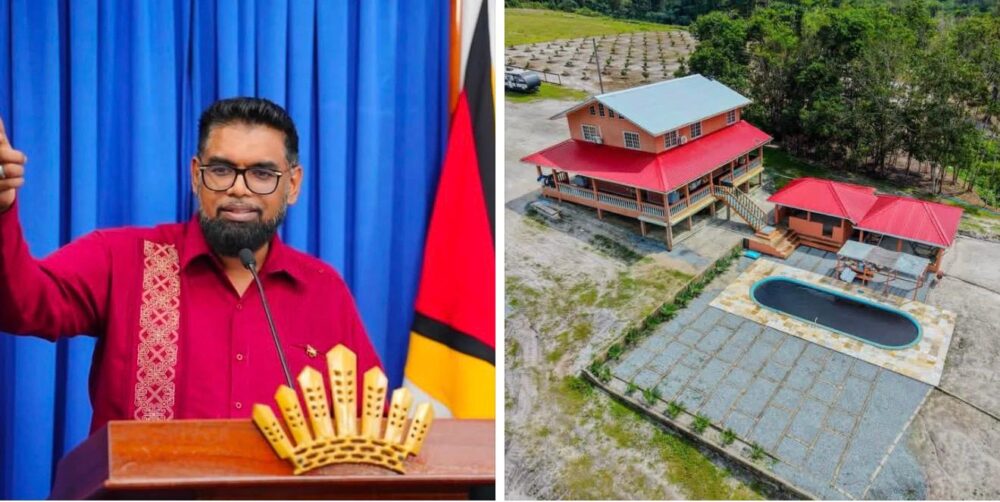
President Irfaan Ali and his Long Creek Farm

President Irfaan Ali and his Long Creek Farm

0
SHARES
0
VIEWS
Share on FacebookShare on Twitter

President Irfaan Ali’s attempt to dismiss allegations about the size of his Long Creek farm has been thrown into question after satellite and geospatial analysis indicated that the property spans approximately 155 acres—contradicting the President’s public claim that Opposition Leader Azruddin Mohamed had grossly exaggerated its size.

The controversy erupted after Mohamed released documentary and photographic evidence that President Ali owns a sprawling multi-billion-dollar farm at Long Creek, along the Soesdyke-Linden Highway. The Opposition Leader placed the size of the property at about 150 acres and questioned how it was acquired, before calling on the President to resign in the interest of accountability and public confidence.

READ ALSO

‘State Jumped the Law’: Todd Says Murder Charges Against MV Barima Crew Defy Shipping Act

Den Amstel Protests Intensify as Residents Demand Granderson’s Release, Ministers’ Resignation Over MV Barima Tragedy

The allegations quickly ignited national debate over transparency, asset disclosure and the standards expected of holders of the country’s highest office.

Breaking his silence on Thursday, President Ali sought to discredit Mohamed’s claims, insisting that the Opposition Leader had fabricated the size of the property.

“The size he gave is not half,” the President declared, accusing Mohamed of having “lied and exaggerated the size of the farm.” He went further, describing the allegation as evidence of “the depth of Mohamed’s lies.”

Ali also defended the legitimacy of his agricultural enterprise, stating: “Integrity. Everything on my farm can be accounted for through legitimate means.”

However, satellite imagery and geospatial measurements tell a different story.
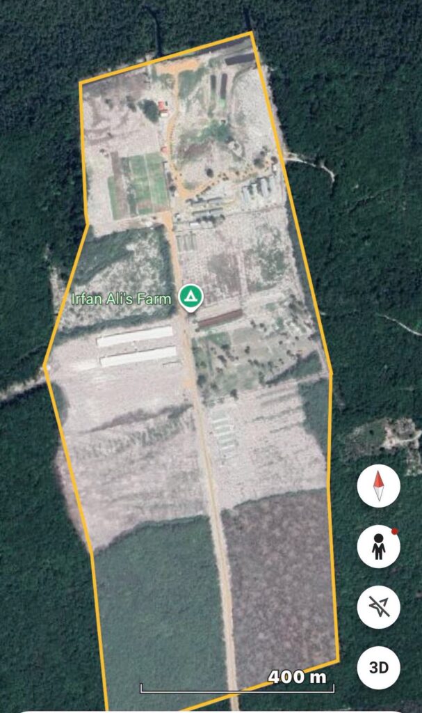
size of President Ali- multi-billion-dollar Log Creek farm (592 Guardian photo)

However, an independent measurement of the property using satellite imagery tells a different story.

Using Google Earth’s polygon measurement tool, the entire visible cleared footprint of the property located at approximately 6°20’44″N, 58°01’W was traced. The analysis calculated the farm’s area at 155.0 acres (627,128.62 square metres), with a perimeter of 3,502.71 metres.

The satellite measurement places the property five acres larger than the estimate provided by Mohamed, directly contradicting President Ali’s claim that the Opposition Leader’s figure was “not half” the farm’s actual size.

If the satellite analysis is accurate, the President’s rebuttal is not merely weakened—it is fundamentally at odds with the measurable dimensions of the property. Rather than demonstrating a gross exaggeration by Mohamed, the geospatial data indicates that his estimate understated the size of the farm.

Google Earth’s polygon measurement tool is widely used by planners, surveyors, engineers, researchers and environmental agencies to estimate land area from high-resolution satellite imagery. While it is not a substitute for a cadastral land survey used to establish legal boundaries, it provides a reliable means of measuring the visible footprint of a property and is routinely relied upon for land-use analysis and planning.

The dispute has therefore shifted beyond political rhetoric to a question that can be independently tested through geospatial evidence.

Although President Ali has maintained that every aspect of his farming enterprise can be accounted for through legitimate means, he has not publicly addressed the satellite measurements showing that the visible cleared property extends to approximately 155 acres.

With Mohamed maintaining his call for the President’s resignation and insisting that the public deserves a full accounting of the property, the controversy is likely to intensify, particularly as independently verifiable geospatial evidence challenges one of the central claims made in the President’s defence.

ShareTweetSendShareSend

Related Posts

Attorney-at-law Dr. Dester Todd
News

‘State Jumped the Law’: Todd Says Murder Charges Against MV Barima Crew Defy Shipping Act

by Admin
July 31, 2026

Attorney-at-law Dexter Todd on Thursday claimed the State abandoned the legal framework governing maritime disasters by charging three MV Barima crew members...

Read moreDetails
News

Den Amstel Protests Intensify as Residents Demand Granderson’s Release, Ministers’ Resignation Over MV Barima Tragedy

by Admin
July 31, 2026

Public anger over the MV Barima disaster showed no signs of easing on thursday evening as coordinated protests unfolded in...

Read moreDetails
News

‘Edghill Must Go’: Joint Opposition, Civil Society Hold Candlelight Vigil Outside Minister’s Home

by Admin
July 31, 2026

The political fallout from the July 18 MV Barima disaster intensified on Thursday night as opposition parties and civil society...

Read moreDetails
Next Post
Students sitting the NGSA

NGSA Results Highlight Winners—And Thousands the System Is Failing


EDITOR'S PICK

The accident scene

29-year-old mother dies in motorcycle accident

October 11, 2020
Dr. Mark Devonish

PPP blame shifting and blackouts

April 7, 2024
Some of the workers who participated in the March and Rally, May 1st 2025

“A nation united can never be defeated,” Lewis tells workers on May Day

May 4, 2025

Wholescale Exclusion of Guyanese at “One Guyana” Energy Conference

March 1, 2026

© 2024 Village Voice

No Result
View All Result
  • Home
  • News
  • Sports
  • Editorial
  • Letters
  • Global
  • Columns
    • Eye On Guyana
    • Hindsight
    • Lincoln Lewis Speaks
    • Future Notes
    • Blackout
    • From The Desk of Roysdale Forde SC
    • Diplomatic Speak
    • Mark’s Take
    • In the village
    • Mind Your Business
    • Bad & Bold
    • The Voice of Labour
    • The Herbal Section
    • Politics 101 with Dr. David Hinds
    • Talking Dollars & Making Sense
    • Book Review 
  • Education & Technology
  • E-Paper
  • Contact Us

© 2024 Village Voice